Calculate Ridge Metrics
This notebook contains the code required to calculate ridge metrics from the previously created datasets:
Ridges
Migration Pathways
Packets
Ridge Area Raster
DEM
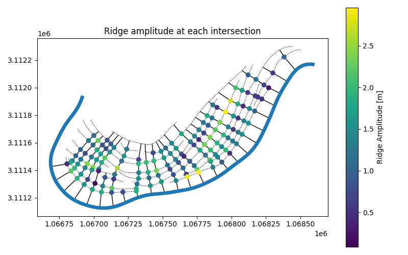
From these datasets, we will calculate ridge width, amplitude, and migration distance at every ridge-transect intersection and plot ridge amplitude on a map.
Output datasets
The calculate_ridge_metrics function takes the transects, ridges, clipped
ridge area (binary) and DEM rasters as input and returns two GeoDataFrames
rich transectsitx points
Rich Transects
The rich_transects retain the same geometry as the input transects but have
the following additional fields:
r_000…r_###: the distance between the channel centerline and that ridge along the specified transectdem_signal: dem values sampled along the transect with 1m samplingbin_signal: binary raster values sampled along the transect with 1m samplingridge_count_raster: the ridge count along the transect calculated from the number of unique ridges inbin_signalfft_spacing: the fft-derived dominant wavelength frombin_signal- corresponds to a representative spacing between ridges along the transect
Intersection Points
The itx points are the collection of point intersections between the ridges
and transects. itx contains the three following ridge metrics in it’s
attribute field:
pre_mig_dist: the migration distance from the previous ridge. Also referred to as “ridge spacing”ridge_width: the width of the ridge derived frombin_signalmeasured in pxridge_amp: the amplitude of the ridge derived fromdem_signalmeasured in units of the DEM
itx also contains the following fields:
start_distances: the along-transect distance to the intersection pointtransect_position: vertex position of the intersection point along the transectmetric_confidence: a simple metric derived frombin_signaldescribing the confidence in other ridge metrics.relative_vertex_distances: the relative along-transect distance of the substring that corresponds to the intersection. A relative vertex position of 0.5 is at the exact midpoint of the transect.vertex_indices: the indices of thedem_signalorbinary_signalof the transect that correspond to the location of the itx substringdem_signal: the section of the transect’sdem_signalthat corresponds to the itx substringdem_signal_selection: a subset ofdem_signalif the intersection point is on the first ridge from the channelbin_signal: the section of the transect’sbin_signalthat corresponds to the itx substringbool_mask:bin_signalexpressed as a boolean arraypost_mig_dist: the migration distance to the next ridgepre_mig_time: the difference indeposit_yearbetween the intersected and previous ridgepost_mig_time: the difference indeposit_yearbetween the intersected and next ridgepre_mig_rate:pre_mig_dist/pre_mig_timepost_mig_rate:post_mig_dist/post_mig_timedeposit_year:deposit_yearof the corresponding ridgesubstring_geometry: theLineStringof the substring corresponding to the intersectiongeometry: thePointgeometry of the intersectionswale_dq_adjustment: values up to this index are removed fromdem_signal,bin_signal, andbool_maskfor calculations. This distance is preserved in the output for subsequent plotting and analysis
from __future__ import annotations

from pathlib import Path

import geopandas as gpd
import matplotlib.pyplot as plt
import rasterio

from scrollstats import calculate_ridge_metrics
# Set input/output paths
# Vector Datasets
ridge_path = Path("example_data/output/LBR_025_ridges_manual_smoothed.geojson")
transect_path = Path("example_data/output/LBR_025_transects.geojson")
packet_path = Path("example_data/input/LBR_025_packets.geojson")
centerline_path = Path("example_data/input/LBR_025_cl.geojson")

# Raster Datasets
bin_clip_path = Path("example_data/output/LBR_025_dem_ridge_area_raster.tif")
dem_clip_path = Path("example_data/output/LBR_025_dem_clip.tif")

# Output
output_dir = Path("example_data/output")
# Read in datasets

# Vector Data
ridges = gpd.read_file(ridge_path)
transects = gpd.read_file(transect_path)
packets = gpd.read_file(packet_path)
cl = gpd.read_file(centerline_path)

# Raster Data
bin_raster = rasterio.open(bin_clip_path)
dem = rasterio.open(dem_clip_path)
# Calculate ridge metrics
rich_transects, itx = calculate_ridge_metrics(transects, ridges, bin_raster, dem)
itx = itx.loc["LBR_025"]

# Join packet info
itx_w_packets = itx.sjoin(packets.drop("bend_id", axis=1))
itx_w_packets = itx_w_packets.reset_index().set_index(
    ["transect_id", "ridge_id", "packet_id"]
)
ridge_metrics_w_packets = itx_w_packets[["ridge_amp", "ridge_width", "pre_mig_dist"]]
ridge_metrics_w_packets.columns = ridge_metrics_w_packets.columns.rename("metrics")
# Plot ridge amplitudes at intersections
# Plot itx
fig, ax = plt.subplots(1, 1, figsize=(8, 5))

ridges.plot(ax=ax, color="k", ls="--", lw=0.5, zorder=0)
transects.plot(ax=ax, color="k", lw=1, zorder=1)
cl.plot(ax=ax, color="tab:blue", lw=5, zorder=2)

itx_w_packets.plot(
    column="ridge_amp",
    ax=ax,
    zorder=2,
    legend=True,
    legend_kwds={"label": "Ridge Amplitude [m]"},
)

ax.set_title("Ridge amplitude at each intersection")

plt.tight_layout()